Riverbanks Community Mobility Plan
The Riverbanks area of northwest Columbia is looking to the future to be better prepared for the possibility of substantial new growth and development. The goal of the Riverbanks Community Mobility Plan is to prepare the area’s infrastructure, chiefly its transportation systems, and land use policies to direct this growth in a way that benefits existing and future residents. These transportation and land use decisions will be guided by a visionary planning process that begins with understanding the people, places, and identities that exist in this area today, working with community members to create a vision for the place Riverbanks should be come, creating new relationships with the area’s riverfront, surrounding neighborhoods, and Downtown Columbia, and expanding mobility options for all residents.
The study area for the Riverbanks Community Mobility Plan sits at the convergence of the Saluda and Broad Rivers and Interstates I-20, I-26, and I-126. It is a short distance northwest of Downtown Columbia and includes the Earlewood neighborhood and Elmwood Cemetery to consider the larger study area’s transition and access to downtown. It includes notable destinations such as the Dutch Square Mall, H. E. Rhame Elementary School, St. Andrews Middle School, and the COMET facilities on River Drive and Lucius Road.
For more information about this plan, please visit our webpage by clicking the logo below:
Columbia East Traffic Improvement Area Plan
The Columbia East Traffic Improvement Area Plan (“Plan”) will develop a comprehensive land use and transportation plan to accommodate existing and future development in the southeastern portion of the City of Columbia generally located around the Garners Ferry Road at I-77 interchange area. The Plan will evaluate existing land uses and potential transportation alternatives to address the long-term, multimodal transportation improvements required to accommodate a potentially significant level of development within and adjacent to the Project area.
The study area encompasses nearly 11,000 acres in southeast Columbia and Richland County. The primary focus of this transportation study is the Garners Ferry Road (US 76) corridor from Fort Jackson Boulevard to Trotter Road.
This area has experienced rapid growth in recent years including residential, commercial, industrial, and institutional uses. However, portions of the corridor remain undeveloped and some land uses are changing.
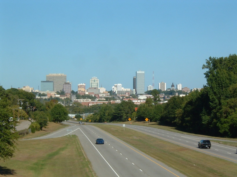
The roadway serves as Columbia’s southeast gateway and provides access to I-77, the VA Hospital, the USC School of Medicine, and Fort Jackson.
For more information about this plan, please visit our webpage by clicking the logo below:
![]()
Regional 2045 Long Range Transportation Plan Update
 The Central Midlands Council of Governments (CMCOG) is updating the Columbia Area Transportation Study (COATS) Metropolitan Planning Organization (MPO) Long Range Transportation Plan (LRTP).
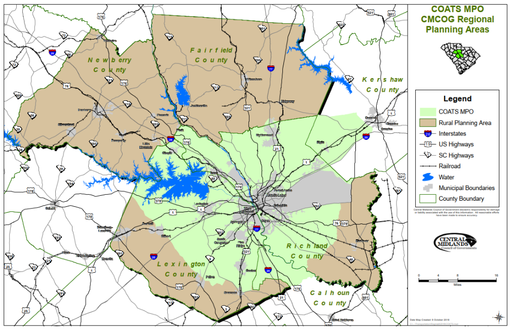
The CMCOG/COATS LRTP is a minimum 25-year plan which must be updated every five years to provide a list of future multi-modal transportation needs for the Central Midlands region. CMCOG is the designated Metropolitan Planning Organization (MPO) & Rural Planning Organization (RPO) responsible for updating the LRTP in coordination with the South Carolina Department of Transportation (SCDOT). The study area includes all or portions of Richland, Lexington, Fairfield, Newberry, Kershaw, and Calhoun Counties.
Because the planning effort must analyze demographic forecasts and current conditions of highways, roads, transit, bicycle and pedestrian facilities, the project will update the LRTP in conjunction with the Regional Congestion Management Plan (CMP) and the Regional Travel Demand Model (TDM). When completed, the CMCOG will have a 2045 LRTP and an updated regional CMP and TDM.
For more information about this update, please visit the completed plan by clicking a logo below:
![]()
![]()
Program Overview
 The Central Midlands Council of Governments (CMCOG) is the designated Metropolitan Planning Organization (MPO) responsible for carrying out the urban transportation planning process for the Columbia Area Transportation Study (COATS). The COATS MPO study area boundary includes large portions of Richland and Lexington Counties and small portions of Calhoun and Kershaw Counties. The primary responsibilities of any MPO are to: 1) develop a Long Range Transportation Plan, which is, at a minimum, a 25-year transportation vision for the metropolitan area; 2) develop a Transportation Improvement Program, which is the agreed-upon list of specific projects for which federal funds are anticipated; and 3) develop a Unified Planning Work Program (UPWP), which identifies in a single document the annual transportation planning activities that are to be undertaken in support of the goals, objectives and actions established in the Long-Range Transportation Plan.
As the MPO, CMCOG provides the forum for cooperative decision making in developing regional transportation plans and programs to meet changing needs. It is composed of elected and appointed officials representing local, state and federal governments or agencies having interest or responsibility in comprehensive transportation planning.
Program Purpose
A metropolitan planning organization (MPO) is a federally-mandated and federally-funded transportation policy-making organization in the United States that is made up of representatives from local government and governmental transportation authorities. In 1962, the United States Congress passed legislation that required the formation of an MPO for any urbanized area (UZA) with a population greater than 50,000. Federal funding for transportation projects and programs are channeled through this planning process. Congress created MPOs in order to ensure that existing and future expenditures of governmental funds for transportation projects and programs are based on a continuing, cooperative, and comprehensive (“3-C”) planning process.
Statewide and metropolitan transportation planning processes are governed by federal law (23 U.S.C. § 134–135). Transparency through public access to participation in the planning process and electronic publication of plans now is required by federal law. As of 2005, there are 385 MPOs in the U.S.
MPO Structure
To facilitate and encourage maximum interaction among these groups and the local community, the CMCOG has an adopted committee structure. The Policy Committee (CMCOG Board of Directors), as the official decision making body, establishes the policies for the overall conduct of the CMCOG, is responsible for the adoption of plans and programs and approves study recommendations. The Executive Committee is made up of Policy Committee members and provides oversight of transportation planning activities. The Transportation Subcommittee, which is established by the Policy Committee, provides a forum for discussion and resolution of relevant issues and monitors technical activities including the development of the UPWP and the Transportation Improvement Plan (TIP) for recommendation to the Policy Committee. In addition, the Transportation Subcommittee directs and considers for recommendation to the Policy Committee all major studies and planning activities.
The Technical Committee, which is established by the Policy Committee, is composed of the professional/technical representatives of the member governments and public agencies having indirect responsibility for transportation planning and/or implementation. Their primary responsibility is to monitor all technical activities including the annual development of a draft UPWP and biennial development of a draft TIP for recommendation to the Transportation Subcommittee. They also consider for recommendation to the Transportation Subcommittee for further discussion and revision before submittal to the Policy Committee for final endorsement of all major studies and planning activities.
Title VI Compliance
Investments made in the TIP must be consistent with federal Title VI requirements. Title VI prohibits discrimination on the basis of race, color, income, and national origin in programs and activities receiving federal financial assistance. Public outreach to and involvement of individuals in low income and minority communities covered under Title VI of the Civil Rights Act and subsequent Civil Rights Restoration Act, and series of federal statues enacted pertaining to environmental justice, are critical to regional planning and programming decisions. The fundamental principles of environmental justice include:
- Avoiding, minimizing or mitigating disproportionately high and adverse health or environmental effects on minority and low-income populations;
- Ensuring full and fair participation by all potentially affected communities in the transportation decision-making process; and
- Preventing the denial, reduction or significant delay in the receipt of benefits by minority populations and low-income communities
- The decision process by which new projects are selected for inclusion in the TIP must consider equitable solicitation and selection of project candidates in accordance with federal Title VI requirements
- The COATS Title VI Plan appears in Appendix A.
For an updated copy of the CMCOG – COATS MPO Title VI Plan & Language Assistance Plan (Click Here)
An Overview of Transportation & Environmental Justice (PDF)
Major Documents
The COATS MPO develops three key documents that are the ingredients to the transportation planning and programming in the Columbia Metropolitan Area: the Long-Range Transportation Plan (LRTP) – the vision; the UPWP or Unified Planning Work Program – the planning; and the TIP or Transportation Improvement Program (updated report coming soon) – implementation and improvement. Together, these three documents represent the beginning, middle and end — the ingredients — to an effective transportation planning process.
Disadvantaged Business Enterprises
The DBE program is intended to ensure nondiscrimination in the award and administration of USDOT-assisted contracts in the highway, transit, and airport programs. The goals of the program are to remedy past and current discrimination against disadvantaged business enterprises, ensure a “level playing field” on which DBEs can compete fairly for DOT-assisted contracts, improve the flexibility and efficiency of the DBE program, and reduce burdens on small businesses.
These goals are, in part, accomplished by providing federal-aid projects with contract goals and implementing the South Carolina Unified Certification Program (SCUCP).
Please follow the link below for an updated copy of UCP DBE Directory. You will find two formats (PDF and Excel) for your convenience:
UCP DBE Directory – Use links at the top of the page to select file download
The UCP DBE Directory is updated weekly.
Public Participation Plan
The Columbia Area Metropolitan Planning Organization (MPO) maintains a public participation process for the development of plans and programs. These procedures for public participation have been formally enacted, reviewed and certified as being in compliance with all applicable federal rules and regulations.
The intent of the Public Participation Plan is to provide meaningful citizen input for the metropolitan transportation planning and programming process through effective citizen involvement activities, accessible information, and opportunities for participation.
To access the CMCOG Public Participation Plan (updated February 2021), please click here.
Plans and Studies
- COATS Transportation Subcommittee Agenda and Minutes
- Transportation Subcommittee Meeting – January 11, 2024-Complete Packet
- Transportation Subcommittee Meeting – November 30, 2023-Complete Packet
- Transportation Subcommittee Meeting – October 12, 2023-Complete Packet
- Transportation Subcommittee Meeting – September 14, 2023-Complete Packet
- Transportation Subcommittee Meeting – August 10, 2023 – Complete Packet
- Transportation Subcommittee Meeting – June 8, 2023-Complete Packet
- Transportation Subcommittee Meeting – May 11, 2023-Complete Packet
- Transportation Subcommittee Meeting – April 13, 2023-Complete Packet
- Transportation Subcommittee Meeting – February 9, 2023 – Complete Packet
- Transportation Subcommittee Meeting – November 10, 2022-Complete Packet
- Transportation Subcommittee Meeting – September 8, 2022-Complete Packet
- Transportation Subcommittee Meeting – August 11, 2022-Complete Packet
- Transportation Subcommittee Meeting – June 9, 2022-Complete Packet
- Transportation Subcommittee Meeting – May 12, 2022-Complete Packet
- Transportation Subcommittee Meeting – April 14, 2022-Complete Packet
- Transportation Subcommittee Meeting – March 10, 2022-Complete Packet
- Transportation Subcommittee Meeting – January 13, 2022-Complete Packet
- Transportation Subcommittee Meeting – December 2, 2021-Complete Packet
- Transportation Subcommittee Meeting – November 10, 2021-Complete Packet
- Transportation Subcommittee Meeting – September 9, 2021-Complete Packet
- CMCOG Rural Transportation Committee
- Rural Transportation Committee – January 18, 2024 – Complete Packet
- Rural Transportation Committee December 5, 2023 – Complete Packet
- Rural Transportation Committee April 26, 2023 – Complete Packet
- Rural Transportation Committee January 12, 2023 – Complete Packet
- Rural Transportation Committee September 8, 2022 – Complete Packet
- Rural Transportation Committee April 27, 2022 – Complete Packet
- Rural Transportation Committee December 1, 2021- Complete Packet
- CMCOG Technical Transportation Committee
- Technical Committee Meeting January 23, 2024-Complete Packet
- Technical Committee Meeting November 28, 2023-Complete Packet
- Technical Committee Meeting September 26, 2023-Complete Packet
- Technical Committee Meeting August 22, 2023-Complete Packet
- Technical Committee Meeting May 23, 2023-Complete Packet
- Technical Committee Meeting April 25, 2023-Complete Packet
- Technical Committee Meeting February 28, 2023-Completed Packet
- Technical Committee Meeting October 25, 2022-Complete Packet
- Technical Committee Meeting August 23, 2022-Complete Packet
- Technical Committee Meeting May 24, 2022 – Complete Packet
- Technical Committee Meeting March 29, 2022-Complete Packet
- Technical Committee Meeting November 30, 2021-Complete Packet
- Technical Committee Meeting August 24, 2021-Complete Packet
- Technical Committee Meeting April 27, 2021-Complete Packet
- Technical Committee Meeting March 23, 2021-Complete Packet
- Technical Committee Meeting January 26, 2021-Agenda & Materials
Major Documents
- CMCOG – COATS MPO Public Participation Plan (Completed February 2021)
- COATS MPO & CMCOG 2045 Regional Long Range Transportation Plan (Completed December 2021)
- 2040 Long Range Transportation Plan (Completed August 2015)
- COATS MPO Congestion Management Plan (Completed January 2022)
- Congestion Management Plan (Completed September 2015)
- FY 2024 & 2025 Unified Planning Work Program (Completed June 22, 2023)
- FY 2022 & 2023 Unified Planning Work Program (Completed May 27, 2021)
- FY 2020 & 2021 Unified Planning Work Program (Completed June 2019)
- FY 2018 & 2019 Unified Planning Work Program (Completed June 2017)
- CMCOG -COATS MPO Title VI Plan & Language Assistance Plan (Completed September 2020)
- CMCOG-COATS MPO DBE PROGRAM (Completed August 2020)
- CMCOG-COATS MPO DBE PROGRAM (Completed August 2017)
- 2020 – 2027 RTIP – Rural Transportation Improvement Program – Completed (March 2024)
- 2020 – 2027 TIP – Transportation Improvement Program – (Completed March 2024)
- 2016 – 2022 Transportation Improvement Program (TIP)
- FY 2013-2019 Transportation Improvement Program (TIP)
- CMCOG Sections 5316 & 5317 Program Management Plan (Completed May 2009)
- CMCOG 2015 Section 5310 Program Management Plan (Completed June 2015)
Regional Plans and Studies
- Three Rivers Bike Share Expansion Study (Completed June 2023)
- Reimagine The COMET Final Recommended Network (Completed September 2022)
- Lower Saluda Greenway Plan (Completed May 2021)
- Human Services Coordination Transportation Plan (Completed September 2020)
- FY 2019 Annual Listing of Obligated Projects (Completed December 2019)
- Regional Freight Mobility Final Plan (Completed November 2017)
- Regional Freight Mobility – Land Use, Infrastructure, and Regulatory Freight Analysis (Completed November 2017)
- CMCOG Regional Transit Needs Assessment (Completed March 2016)
- South Carolina Statewide ITS Architecture (Completed February 2015)
- Newberry-Columbia Alternative Analysis (Completed March 2014)
- Regional Congestion Management Plan: Completed October 2008)
- Regional Motor Freight Transportation Plan: (Completed December 2008)
- Human Services Transportation Coordination Plan: (Completed September 2007)
- Regional Bicycle & Pedestrian Plan: (Completed March 2006)
- CMCOG Commuter Rail Feasibility Study(Completed July 2006)
- Midlands Air Quality Report (Completed June 2007)
- Public Participation Plan (Completed March 2010)
- Annual Listing of Obligated Projects (Completed June 2010)
Transportation and Land Use Studies
- Chapin S-48 Columbia Ave Corridor Study (Completed August 2006)
- S-48 Appendix A – Summary of Previous Planning Documents
- S-48 Appendix B – Summary of Stakeholder Meetings
- S-48 Appendix C – Existing Traffic Conditions
- S-48 Appendix D – Newberry SmartRide Schedule
- S-48 Appendix E – Impact Fee Process & SC Laws
- S-48 Appendix F – Traffic Conditions with Recommended Alternatives
- S-48 Appendix G – Order-of-Magnitude Cost Estimates
- S-48 Appendix H – Potential Funding Sources
- Blythewood Traffic Improvement Area Plan Final Report (Completed June 2019)
- Sandy Run Area Plan Final Report (Completed June 2019)
- Chapin, Swansea, & Batesburg-Leesville Bike and Pedestrian Master Plan (Completed May 2019)
- Cayce, West Columbia, & Springdale Bike and Pedestrian Master Plan (Completed December 2017)
- Cayce, West Columbia, & Springdale Bike and Pedestrian Master Plan Appendices (Completed December 2017)
- Cayce, West Columbia, & Springdale Bike and Pedestrian Bike Share Plan (Completed December 2017)
- Kershaw County – West Wateree Transportation Study (Completed April 2017)
- Walk Bike Columbia Bike and Pedestrian Master Plan (Completed March 2015)
- Walk Bike Columbia Bike Share Plan (Completed March 2015)
- White Knoll Sub Area Plan (Completed December 2008)
- Lower Richland Sub Area Plan (Completed May 2008)
- Broad River Road Corridor & Community Study (Completed December 2010)
- Batesburg-Leesville / Columbia Transit Feasibility Study (Completed July 2010)
- Irmo / Dutch Fork Sub-Area Plan (Completed June 2010)
- Elgin / Richland Northeast Sub-Area Plan (Completed June 2010)
Projects currently under development
- Columbia East Traffic Improvement Area Plan
- Riverbanks Land Use and Transportation Study
- Regional Congestion Management Plan Update
- Regional Bike and Pedestrian Master Plan
- US 1 Corridor Feasibility Study
- Corley Mill Road / Andrew Corley Road Corridor Feasibility Study
- Regional Passenger Rail Feasibility Study